
|
Heading |
Location |
Administrative entity |
|
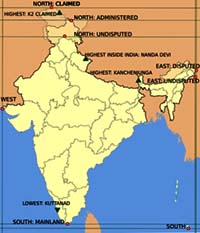
North (disputed, administered) |
Near Indira Col, Siachen Glacier |
Indian-administered Kashmir |
|
North (disputed, claimed) |
Dafdarin the Taghdumbash Pamir near Beyik Pass |
Xinjiang, China |
|
North (undisputed) |
Near Dharwas, Chamba district |
Himachal Pradesh |
|
South |
Indira Point in the Nicobar Islands |
Andaman and Nicobar Islands |
|
South (mainland) |
Cape Comorin near Kanyakumari |
Tamil Nadu |
|
East (disputed, administered) |
Kibithuin Anjaw district |
Arunachal Pradesh |
|
East (undisputed) |
Near Kumki, in the Changlang district |
Arunachal Pradesh |
|
West |
Guhar Moti in Kutch, near the Sir Creek |
Gujarat |
|
Extremity |
Name |
Altitude |
Location |
|
Highest (undisputed) |
Kanchenjunga |
8,586 m (28,169 ft) |
North Sikkim on the India-Nepal border |
|
Highest (disputed) |
K2 |
8,611 m (28,251 ft) |
Border between Kashmir and Xinjiang |
|
Highest (undisputed and entirely with in India) |
Nanda Devi |
7,816 m (25,643 ft) |
Garhwal Himalaya |
|
Lowest |
Kuttanad |
−2.2 m (−7.2 ft) |
Alappuzha district |